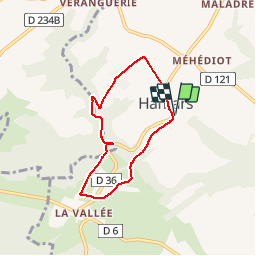
Hamars

Jeff_314
User

Length
5.4 km

Max alt
219 m

Uphill gradient
163 m
Km-Effort
7.5 km

Min alt
98 m

Downhill gradient
162 m
Boucle
Yes
Creation date :
2014-12-10 00:00:00.0
Updated on :
2014-12-10 00:00:00.0
1h47
Difficulty : Easy

FREE GPS app for hiking
 SityTrail
IGN / Geographical institutes
SityTrail Plus
The world is yours!
About
Trail Walking of 5.4 km to be discovered at Normandy, Calvados, Le Hom. This trail is proposed by Jeff_314.
Description
Autour d'Hamars
Positioning
Country:
France
Region :
Normandy
Department/Province :
Calvados
Municipality :
Le Hom
Location:
Hamars
Start:(Dec)
Start:(UTM)
679544 ; 5430088 (30U) N.
Comments